I’ve been in the great state of Virginia for nearly two weeks now, and so far it’s been some of my smoothest time on the trail yet. I apologize for not posting in such a long time, cell signal, much less mobile data, have been sparse at best. I’ve also been short on places to charge my phone, in addition to the challenge of writing itself. My phone also has a nasty habit of erasing big chunks of documents I thought were securely saved, setting me back hours. Then there’s the bug factor to consider… I do most of my writing after dark, and if I don’t keep my phone on the lowest brightness setting, it attracts every nocturnal insect in the Jefferson National Forest. I accidentally squished a lacewing with my right thumb trying to type this sentence. File that one under things I never anticipated would interfere with my writing.
#AppalachianTrail2016 #yearofadventure #backpacking #whiteblazers #optoutside #mountains #nature #forest #benchmark
For northbound AT hikers, Virginia is thought of as a near-unfathomable promised land throughout the time we’re in the Smokies, lower Carolina, Tennessee, etc. “If I can just make Virginia, I’ll have it made.” How many times I’ve heard that. How many times I’ve said it. Because regardless of reality, the perception is, reaching Virginia equals hitting your stride.
When I was in Scouts, I attended a program called Green Bar NYLT, which stood for National Youth Leadership Training. It included a portion on skill development which described the four phases of mastering a new task: Forming, Storming, Norming, and Performing, and it’s stuck with me in the ten years since. Probably because I still have the wallet card, complete with a little four-point compass rose illustrating each step.
During the Forming stage, enthusiasm is high and skills are low. Everything is new, and exciting. All aspects of the new thing are cool and unique. You don’t have a clue what you’re doing, but it doesn’t matter. You will, and you know it. It’ll only be a matter of time before you’re an expert, and you can’t wait until then.
Storming is when you hit the wall. Reality picks up a tree limb and whacks you in the face with it, and you’re forced to reckon with the realization that this isn’t going to be as easy as you thought. Skills are still low, but now, so is your enthusiasm, sucked away by newfound difficulties and ever-present frustration.
But then Norming happens. Slowly, sometimes imperceptibly, it starts getting easier, and you realize that you haven’t been struggling as hard lately. You still stumble, and there’s still plenty of room for improvement, but you start to notice that some aspects of the skill have become second nature. Your frustration levels drop by the day as your comfort level with the skill increases. After a long crawl, you’re learning to walk.
Performing, of course, is where skills and enthusiasm are both high. You love the thing like you did at the start, but you love it all the more for knowing it. You’re owning it. All you do is win. Not really. But it feels like it. Mastery is a feeling with few competitors, because it’s a feeling that has to be earned. You don’t just wake up feeling capable one day.
I may not be Performing yet, but after 600 miles of Forming and Storming, I think it’s safe to say that I’m finally Norming. I’ve been out here long enough that the memories of my life before this trip are fading. I can still feel what it was like, but the sharpness is gone. Anything fresh in my mind is a swirl of miles, elevation profiles, food drop logistics, mountain vistas, hiker-town grocery store runs with trail family, forest sunsets, rocks, roots, wind, sun, rain, and thousands upon thousands of green, green trees.
A few weeks ago, I crossed out of Tennessee and down the ridge into Damascus, Virginia. My fourth state, and along with Mt. Rogers, 30 miles further along the trail, the traditional quarter-point of the AT.
Northbounders have a justified reputation as a party crowd, but for most of this trip, I haven’t been partaking. My attitude is that there hasn’t been anything to party over or celebrate yet,unless you’re just looking for an excuse to drink and take another zero. But in Damascus, I took an evening to cut loose. I was eating an entire burrito platter and washing it down with a Dos Equis at Hey Joes when I got a text from Whojo, the first guy I met on this trip – 30 minutes into the approach trail at Amicalola. He asked if I was in town, and if I wanted to join him, Shatterproof, Sota, PBS, and several others at The Broken Fiddle hostel across town. Of course I did, I hadn’t seen some of these guys in weeks, but instead, they changed their mind and told me to hang tight where I was, and that they were coming to join me. To say it was an awesome reunion was an understatement. Shatterproof bought the house a round of Jack, and we decided to break loose and head across town to the Second Annual Beaver Dam Jam Music Festival in the park by the river. Local bands of varying levels of talent took over the pavilion stage. The last one and best one, headed by a music minister from one of the local churches, played a righteous mix of southern rock, blues, folk, and hillbilly dance music and started taking requests. One dude yelled out from the crowd, “PLAY COPPERHEAD ROAD OR I AIN’T COMIN’ TO CHURCH TOMORROW!” I love small towns, y’all. An evening of great music amd even better company was the perfect way to celebrate this milestone. Later, we jointly decided to go for a resupply at Food City across town, and persuaded Bonnie, the owner of the Broken Fiddle, to drive us. Only problem was, there were six of us, and she drove a Mini Cooper. I’m not sure how, but we made it work. At Food City we had an even bigger hiker reunion – Blaze, Littlefoot, Bambi, Elsa, Waffles, and a handful of others had the same idea. It’s moments like this, as Elsa put it, that are the real trail magic. When you can go into a town you’ve never been before, make a midnight food run, and meet a dozen friends, some old, some you just met. That’s special, and that’s unique.
The next morning, I took the opportunity to go to church, my first time since I’ve been on the trail. Although the traditional worship at Damascus United Methodist might not have been quite my speed, it was wonderful to be in the company of other believers again in contrast to the almost entirely non-Christian community on the trail. I was treated with incredible kindness and hospitality, a ragged, barely-showered thru-hiker in this congregation of impeccably dressed and groomed parishioners.
I also took the time in Damascus to make some changes to my gear and lighten my pack. If you were wondering about the “unforseen expenses” that I referred to in my request for donations to my gofundme account, these are them. In the hundred miles or so leading up to that point, my feet had been getting progressively worse, to the point that any step I took after about ten miles or so felt like I was being stabbed in the foot. I mentioned it at Woodchuck Hostel and the term Plantar Fasciitis came up, so I googled it, and sure enough, it fit my symptoms perfectly. An inflammation of the plantar fascia, the tendon that runs the length of the foot, it’s common to anyone who does a significant amount of walking, and is extremely painful. So in order to remedy my symptoms, I purchased a pair of Superfeet insoles, a gigantic bottle of off-brand Tylenol, and cut my pack weight drastically. I sent several pounds of gear home, including my rain gear, and I bought an ultralight summer weight sleeping bag, new pad, and several other items. The good news is that it seems to have worked. My feet still hurt, but it’s the normal kind of hurt that you get from hiking fifteen to twenty miles per day, not the kind that takes your breath away with every step. The bad news is that it didn’t come cheap, so I want to extend a huge thanks to everyone who has contributed to my gofundme account. I’m not quite out of the hole yet, so any further contributions are still appreciated. I’m also probably not done with major purchases – the boots that I was hoping would get me the whole way to Maine are looking like they’ll last exactly halfway. So I’ll be needing another pair in less than a month, to the tune of $300.
It’s taken me almost three months off and on to get this far. My pace has picked up, and is continuing to pick up, significantly. I pulled my longest day yet recently – 23 miles. It took me almost all of April to struggle my way from Amicalola Falls to the near-vertical final mile up Albert Mountain, mile 100. It took me nearly three more weeks to claw my way up the freezing slopes of Clingman’s Dome. But since then, the hundreds have started to roll off easier and easier. I wrote this paragraph on 6/23, the day I climbed Mt. Rogers (Virginia’s highest point at 5,729 feet), and passed mile 500 in Grayson Highlands State Park, and it was less than ten days ago that I crossed mile 400 after the Roan Highlands. It sure does feel good to finally be making progress, and it feels even better to be in a state that doesn’t touch Georgia.
Speaking of Roan Highlands, this section I’ve hiked since my last post has been quite possibly the most beautiful yet. They were a relatively short section of trail, but they’re my favorite so far.
They deserved their own post, but alas, I never wrote it. One of the best problems I have out here is that I experience far too many stories to realistically blog about. That’s a big reason why most of my posts are so long – it’s hard to leave these stories untold.
#AppalachianTrail2016 #yearofadventure #exploring #backpacking #whiteblazers #optoutside #mountains #nature #scenery #beauty #hiking #azalea
There’s so much to say about Roan Highlands, but I’ll leave it at this: The top of Hump Mountain affords 200-mile views of three states. Mt. Mitchell in North Carolina, Clingman’s Dome in Tennessee, and Mt. Rogers in Virginia are all visible. Nearly all of the trail in this section is exposed, open to the Tennessee sky. It hops from one rocky, grassy bald to another, only occasionally dipping down into the trees. Rhododendrons, flame azaleas, and mountain laurels are the tallest things growing, and are positively alive with loud sprays of blossoms in hot pink, neon orange, buttery yellow (flame azaleas can bloom in over a dozen different shades ranging from a deep red to a pale yellow and everything in between, depending on the type of soil they grow in), and bright, pink-tinged white. Grass grows knee-high, and moves like the currents of an ocean with every shift of the wind. I can authentically say that out of all the places I’ve been, I’ve never seen anything like it. I don’t know what Heaven looks like, but if I had to guess, I’d say that it’s probably a lot like the Roan Highlands.
For whatever reason, maybe just wishful thinking, there’s always the trail rumor that the upcoming section of trail is always going to “flatten out” and “get easier.” I first heard that in the Smokies, and I’ve been hearing it ever since. And it’s still just as much crap as it ever was. Nearly every northbound thru-hiker, myself included, fell for the myth that Virginia is a land of milk and honey, as well as low, rolling, easy ridgelines and flat, rock-free trail. Lies, every bit of it. Virginia is not flat, and it is not easy. It does flatten out in the sense that big, dramatic mountain ascents are fewer and farther between, and that the altitudes are generally lower. For instance, Mt. Rogers is the highest peak I have to look at until I reach New Hampshire. But in place of the high mountains are a succession of short, steep, nasty little rollercoaster climbs and drops of about 100 vertical feet at a time. The elevation profile in the guide looks essentially flat, but bumpy. The actual trail is a constant up and down over sharp rocks embedded in the ground and filled in with razor-edged golf ball sized talus that’s just the right size to send your foot out from under you on steep ascents and descents. The true elevation gain over the course of a day can be as much as 3,000 feet.
modern_day_mountain_man”Oh, give me land, lots of land under starry skies above,
Don’t fence me in.
Let me ride through the wide open country that I love,
Don’t fence me in.” – Cole Porter, 1934
#AppalachianTrail2016 #yearofadventure#exploring #backpacking #whiteblazers #optoutside #scenery #nature #mountains #hiking #nofilter
But another myth about Virginia is that it’s boring, and that’s one I’m glad to say is false as well. Most people told me that the state is just “green tunnel,” that is, endless plain miles through featureless terrain and trees that look essentially the same. The green tunnel phenomenon is not unique to Virginia. Now that it’s summer, most of the AT is just a hollowed-out cut in the thick temperate hardwood rainforest that covers the Southern Appalachians. But the trees here are punctuated regularly by beautiful farm country, bald, open ridgelines, and miles of natural rock gardens with boulders the size of houses. Virginia is without a doubt some of the prettiest hiking I’ve done yet. As I’ve said before, each section of the trail has its own unique character, and the same holds true again here. Whereas some of the lower portions of the trail were true, hardcore roadless wilderness, and celebrated that fact, southern Virginia showcases the most beautiful sides of both the woods and quiet middle American farmland.
The trail alternately passes between open, friendly woodland, and pastureland dotted with ancient, sprawling oaks. Cattle graze freely, both on private land that the trail has easement through, and public land where ranch owners have purchased grazing rights. Unlike further south, where nearly all barns are a standard peak-roof timber-frame construction, the barns of southern Virginia are the art’s highest form. They range in size from tiny outbuildings to enormous, three-story warehouses that dwarf the farmhouses. Every size, shape, and color is represented, and you’ll see a totally unique one in each and every agricultural valley you cross.
One of the most noticeable changes between Virginia and the trail further south is the livestock. I’ve had more close encounters with cows in the past three weeks than I have in the past three years. Coming up out of Elk Garden before I reached Grayson Highlands, I was buzzed by three Marine Corps V-22 Ospreys out on training maneuvers flying no more than three hundred feet over the exposed, grassy ridgeline. As they left, I heard a constant low mooing, and sure enough, I crested the ridge and beheld a herd of some fifty mixed cattle, agitated by the low-lying aircraft and standing squarely in the middle of the trail.
I made my way through them as best I could, sidestepping when necessary. An enormous black Angus herd bull, probably well over a ton, stood grazing with his front end quartered away from me, standing across the trail. He heard me coming up behind him and looked over his shoulder at me. He stared me down, chewed his cud, and went back to grazing without budging an inch. I went around.
Three curious calves started following me, and when I heard them and turned around, they spooked. This was no big issue in and of itself, except for the fact that it made Momma Cow think something was trying to hurt her babies and that maybe she should try and knock it flat just in case. She came at me faster than a thousand-pound animal should be able to move, until I calmed her down while backing away quickly. I’m glad for all the time I spent around cows growing up, and learning their behavior and how to interact with them. I’ll be throwing that one in the pile of skills I never thought I’d need to thru-hike the AT.
Grayson Highlands has a long, storied history of cattle ranching and freegrazing. Towards the end of the 19th century, honest-to-God, horse-riding, pistol-toting cowboys rode the high balds and rounded up cattle to be driven to market at a highland corral called The Scales, the remnants of which still exist today, and is cut straight through by the Appalachian Trail. The name comes from the fact that cows were weighed and sold here, in the remote and rugged Grayson Highlands, rather than in town, because ranchers quickly realized that they made more money selling them at their “highland weight” rather than after the long trek out of the mountains.
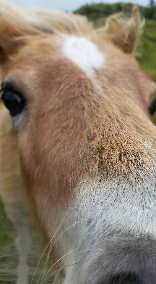
But the real stars of Grayson Highlands are the ponies. Introduced to the area by the Forest Service in the late 1960s, the herd is carefully managed and numbers over a hundred. And all I can say is, they’re not what I expected. My only prior experience with wild horses was on Cumberland Island, Georgia this past March. Those, descendants of Spanish war horses set free over 400 years ago, were truly wild animals – rangy, skittish, and occasionally aggressive if approached too closely. These ponies were nothing like that. I had been told that they were friendly, but I didn’t realize just how friendly. The first herd I got close to was grazing idly in a rocky meadow maybe a hundred yards off the trail. I approached cautiously, remembering how quick the horses of Cumberland were to kick or bite, if they didn’t bolt first. But this herd didn’t really care. These were some chilled-out equines. I got close to a paint mare who didn’t even look up from cropping grass until I reached out to pet her, and then reached over with her mouth… to nuzzle my hand. That’s when I realized what I was dealing with. I took pictures, selfies, and video with several of the ponies, and the whole time the biggest concern I had was keeping them from eating my gear. (Trust me, they tried. Especially the straps on my trekking poles, for some reason.) The Grayson Highlands ponies are just bigger than Shetland size – about half the size of an average horse. And the best word for them is, well… cute. A fresh foal from this spring decided to adopt me, and followed me around as I took pictures of its herd mates. It kept nudging me, nibbling me, amd trying to play. It didn’t seem to want food, just to be petted. It stayed by my side with me until I hiked away, reluctantly.
The Grayson Highlands were a unique and wonderfully strange part of the trail – a fantasy land of rocky, treeless meadows full of rare wildflowers and tame ponies. Damascus was an awesomely friendly and quaint trail town, with a lot of great memories made there. And they were both a lovely introduction to Virginia. I’ll have the most miles in Virginia out of all the states the AT cuts through – over five hundred in all. Here’s to hoping the rest of them are as sweet as the last hundred.
One thought on “Sweet Virginia”
Hike on….the for sharing your adventure.
Vernon ~ Canton,GA